
QuickMap, the Caltrans app that gets better and better
Recent additions include tools for commercial vehicles and road closure push-notification options
“For the most current traffic and road closure info, turn to Quickmap.dot.ca.gov.”
That little statement from District 10, a region containing several Sierra Nevada highways that often close due to snowfall or rockslides, is a common suggestion shared by Caltrans public information officers (PIOs) when they are advising the public on how best to prepare for driving in inclement conditions.
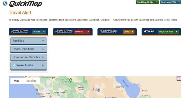
For those who don’t know, Caltrans’ QuickMap is a mobile app and website available to the public at no cost for travel planning. QuickMap provides immediate traveler information, including traffic speed, lane and road closures due to construction and maintenance activities, emergency incidents, electronic highway message sign content, rest area locations and amenities available, CCTV camera snapshots, and active chain control requirements.
This real-time traveler information tool, overseen by the Division of Traffic Operations, has added a few new features. Last year, QuickMap was augmented with push notifications, and this summer it added a “Commercial Vehicles” option.
On June 29, Caltrans introduced the Commercial Vehicles layer via social media. Its features include truck weigh station locations and color-coded California truck networks. Here’s a primer on how to use this new function:
- Select "QuickMap Options."
- Select the "Commercial Vehicles" layer from the dropdown menu.
- Select "Truck Weigh Stations" to view the locations of statewide weigh stations. Uncheck to remove them from the map.
- Select "California Truck Networks" to view color-coded routes on the map. Uncheck to remove them from the map. Those colors represent National Network Route (green), Terminal Access Route (blue), California Legal Route (black), California Legal Advisory Route (yellow) and Special Restriction (red).
More features within the Commercial Vehicles layer are being pursued, and soon will go “live.” Those possible additions include data points about truck-escape ramps, truck service access and truck terminal access. Real-time wait times southbound at California-Mexico border crossings is information that has long been offered on QuickMap; the addition of northbound wait-time postings is still being developed.
In August 2022, Caltrans launched the push notification feature on its QuickMap app that allows all drivers to automatically receive real-time notifications about nearby road and rest area closures.
The push notification feature allows travelers to opt in to receive location-based alerts on their mobile devices. When a device with the QuickMap app enters an area within 10 miles of a road closure, a pop-up message will appear alerting travelers of the incident, including time, location and reason for closure.
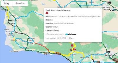
Truckers can consult QuickMap to help determine the best route to take depending on evolving circumstances.
QuickMap screenshot
QuickMap is an increasingly helpful travel-planning tool for anyone driving in California. Caltrans PIOs continually encourage its use through media interviews and social-media posts. For example, District 9 is especially active in QuickMap promotion, as it contains the eastern portions of District 10 highways (including State Routes 4, 104 and 120) that cross the Sierra Nevada.
District 2, a North State region that encompasses many mountain roadways, also makes a point of plugging the app.
“We primarily promote QuickMap as the most reliable and up-to-date resource for roadway information in our district and state,” says Denise Yergenson, District 2’s chief PIO. “We also use QuickMap in our office as a resource for gathering current roadway information and accurate details to pass on to the traveling public through our social media outlets and callers to our district phone. QuickMap has proven to be a user-friendly resource that all can use while traveling through our district and throughout the state of California.”
Find out more about QuickMap on this Caltrans webpage, which contains a list to frequently asked questions about the app.
Caltrans reminds drivers to use their mobile device responsibly, including only in hands-free mode when operating a vehicle. Using your cell phone while driving is not only dangerous, but illegal. In California, drivers 18 and older can only use their phones in a hands-free manner, such as speaker phone or voice commands, but never while holding it.
Source: Division of Traffic Operations, Headquarters Public Affairs